Killimer
Killimer and its townlands have gone through many variations of spellings, even when translated to Irish it has changed through the years – Cill Imí /Cill Iomair/ Cill Aodhmaide (as in the Killimer school Irish copies in 1920’s). We found these samples in our research, from many different maps.
- Cill Iomaighe 13th and 16th century, Thomond Map used the term Tuath Acaidh Meadhonaigh.
- Killeyme in Map of John Cary, 1799.
- The townland of B.Crana (Baile Crana) first appeared in the 1750 Edition, no doubt Ballymacrinnan.
- Clonderlaw appeared for the 1st time in 1796 map.
- Killeymer was the spelling used in 1798 by William Faden.
- Killeyme was the spelling used in John Pinkerton map of 1812, his more detailed work of 1813 included Mullough believed to be Molougha.
- Sidney Hall in his map of 1830 included Burnaan believed to be Burrane.
- Killeime was the spelling chosen by Daniel Lizars in his 1831 map.
- Killeimer was the spelling used by John Arrowsmith in 1844.
- C.F. Weiland included Barrane in his map of 1853.
- Killimer was the spelling used in 1861 by Alexander Keith Johnston in his very accurate map.
Our townlands have likewise gone through many different spellings and translations. the following are all our townlands to the best of our knowledge.

To with the placement of the townlands here is our parish map again.
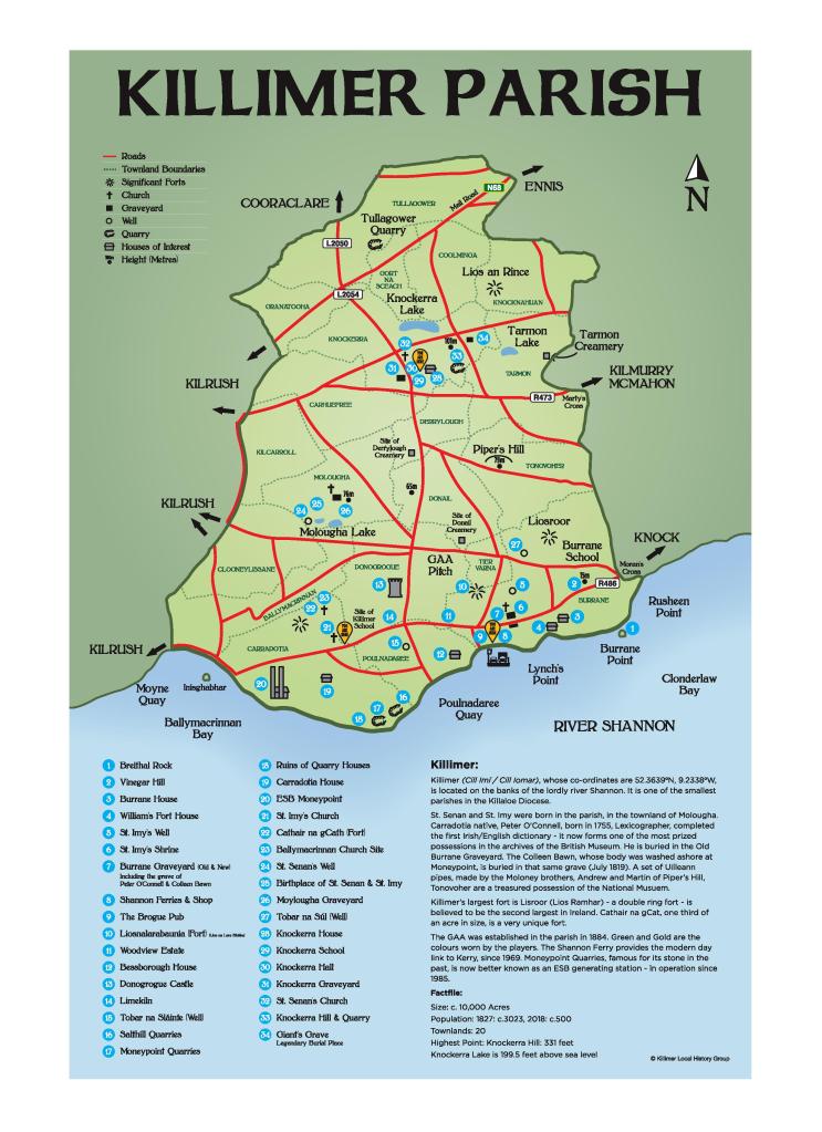
BALLYMACRINAN
475 acres – Clonderlaw
Baile Mac Rianáin – MacRinan’s abode (the name MacRinan is now extinct in the parish)
BURRANE
1059 (Burrane Upper – 361 acres, Burrane Lower – 698 acres – Clonderlaw)
Biorán – pin or point
Or
Barrán – a low hill
CARRADOTIA
795 (Carradotia North – 323 acres, Carradotia South – 472 acres – Clonderlaw)
Ceatramadh Doitiadh (Ceathrú Doite) – The burned townland or quarter; burning of the surface of the land was burned much practiced in Ireland up to recent times.
CARROWFREE (CARHUEFREE)
551 acres – Barony of Moyarta
Ceathru Fraoich – The heathered quarter
Or
Ceathramhadh Freadh – Place of plunder
TRELLIG : (not an official townland, it is part of Carrowfree townland)
Trí Liaig – Three standing stones – believed to have been on the farm of Denis Moloney (now Brenden Crowe’s) in Trellig. Standing stones next to ring forts and burnt mounds are probably the most numerous type of monuments in Ireland. They served many and varied functions through the ages as pre historical burial markers, commemorative monuments and indicators of routes or boundaries – some were just scratching posts for cattle.
CLOONEYLISSANE
513 acres – Clonderlaw
Cluaine Ui Lissane – Lissanes meadow or aftergrass.
MONEEN: (not officially a townland)
Moinín – Small piece of bogland
COOLMINGA
357 acres – Barony of Moyarta
Cúl Mionga – Land at the back or end of the marsh/swamp
DERRYLOUGH
236 acres – Barony of Clonderlaw
Doire Locha – Oak wood beside the lake
CRAGG: (not officially a townland)
Creig – stone or barren land
DONAIL
416 acres – Barony of Clonderlaw
Dun an Néill – Fortress of the O’Neill clan
DONOGROGUE
695 acres – Clonderlaw
Dún na Geabhróg – Fort of the sea Tern
or
Dún na gCorróg – fort made thick with sheaves / bundles of faggot
KNOCKAFONTA – (not an officially recognised townland but part of the Donogrogue townland)
Cnoc an phónta – Serviceable hill (useful)
GORTNASCEACH
163 acres – Moyarta
Gort na Sceach – Garden of thorns/bushes. (Sceach was the Irish for the whitethorn bush)
GRANATOOHA
286 acres – Barony of Kilmacduane
Gearrán Tuatha – Horse or nag country
Or
Gránna Tuatha – Disagreeable (ugly) country.
KILCARROL
712 acres – Barony of Moyarta (a part of the townland is in Kilrush parish)
Cill Cearbhall – Church of Carrol [Carrol some people in the past thought he was a brother of Senan]. Many deceased parishioners were buried in the graveyard in Kilcarrol.
KNOCKERRA
695 acres ( Knockerra East – Barony of Clonderlaw, 232 acres and Knockerra West Moyarta – Barony of Clonderlaw,463 acres)
Cnoc Aodhaire – Hill of the Shepherd
Or
Cnoc Doire – Hill of the Oak wood
Or
Cnoc Dara – Hill of the Giant Dara
KNOCKNAHUAN
This townland was in two Baronies – 179 acres – Barony of Clonderlaw , 212 acres – Barony of Moyarta
Cnoc na hUan – Hill of the lambs
MOLOUGHA
508 acres – Moyarta
Magh Locha – Field beside the lake
POULNADREE
315 acres – Clonderlaw
Poll idir dá doire – an open space between two wooded areas
or
Poll na nDraoí – dwelling or place of druids
TARMON
666 acres – Barony of Clonderlaw
Tearmann – Church land or sanctuary
TIERVARNA
88 acres – Clonderlaw (The Cunningham family are now the sole landowners of this townland)
Tír an Bhearna – The place of the gap or chasm
TONOVOHER
531 acres – Barony of Clonderlaw
Tóin an bhothair – End of the road
TULLAGOWER
881 acres – Barony of Moyarta
Tulach Gabhar – Hill of the goats
SHANVALLA: (not officially a townland but a recognised place name in the townland of Tullagower.)
Sean Bhaile – Old town
